Agricultural Land Certificate
(ALC)

Abbildung 1: Satellitenbilder für Due Dilligence
Agrarland-Investments mit satellitengestützter Bewertung
Die im schweizerischen Thurgau beheimatete Spatial Business Institute AG (SBI AG) hat mit dem „Agricultural Land Certificate“ (ALC) ein neues Kapitel der Bewertung von land- und forstwirtschaftlichen Flächen aufgeschlagen. Auf der Basis von Satellitenbildern und datenbankbasierten weiteren Informationen ist nun eine sichere und nachhaltige Bewertung von Investitionen möglich.
Einer der ersten Auftraggeber war die Do Investment AG aus München. Sie beauftragte die SBI AG, ein potentielles Investmentobjekt in Uruguay anhand von Satellitenbildern zu analysieren.
Das zum Erwerb stehende Farmobjekt wurde durch die Do Investment AG bereits zweimal besichtigt und anhand von Bodenproben untersucht. Die entscheidende Frage war, welcher faire Preis für das Objekt angesetzt werden konnte. Um neben dem Ist-Zustand der Farm auch die historische Bewirtschaftung und Zukunftspotenziale zu analysieren, wurde mit Hilfe von Satellitenbildern und datenbankbasierten weiteren Informationen ein detailliertes Gutachten erstellt, das letztendlich die Kaufentscheidung der Do Investment AG bestärkte.
Neutrale Beurteilung
„Satellitensensoren erfassen Standort- und Pflanzeneigenschaften objektiv, präzise und informationsreicher als das menschliche Auge“, erläutert Dr. Jürgen Born, Vorstand der SBI AG, sowie Geschäftsführer von Spatial Business Integration (SBI) in Darmstadt, einem der weltweit führenden Anbieter satellitenbasierter Dienstleistungen für das Agrobusiness und die Finanzindustrie. Dr. Dirk Rüttgers, Vorstand der Do Investment AG war von Anfang an überzeugt, mit der SBI AG den richtigen Partner für agrar- und fortwirtschaftliche Investitionen gefunden zu haben.
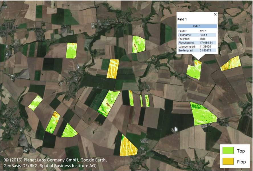
Abbildung 2: Bewertung von Agarflächen durch Satelliteninformation
„Das Agricultural Land Certificate umfasst weit mehr als eine klassische Due Diligence“, stellt Dr. Rüttgers fest: „Die klassischen Aspekte einer Prüfung, wie wirtschaftliche, rechtliche oder politische Punkte, werden ergänzt und in einen neuen Kontext gestellt. Das ist der entscheidende Vorteil des ALC.“
Mit den detaillierten Satellitendaten werden weitere Faktoren wie Wetter- und Boden-Werte und nicht zuletzt Klimaprognosen verknüpft. Durch die Analyse dieser Standortfaktoren kann das Ertragspotenzial sicher bewertet und durch die Verwendung von Klimaszenarien auch in die Zukunft fortgeschrieben werden. Für diese Gutachten, so Dr. Born, lägen verlässliche Wetter- und Satellitendaten von mindestens einem Jahrzehnt vor. Nur so lassen sich verbindliche Aussagen zur Werthaltigkeit von direkten Agrarinvestments machen.
Was sich anhört wie das Prinzip „Ergebnis auf Knopfdruck“ basiert in Wirklichkeit auf jahrzehntelanger Erfahrung im Umgang mit Satelliten- und Geo-Daten und umfassender Expertise der Agraringenieure von SBI. Erst dadurch werden Statusdiagnosen und Simulationen zu Fakten, die der zuverlässigen Beurteilung einer Investition dienen. Zusammen mit wirtschaftlichen Standortgutachten minimieren diese Informationen Fehlinvestitionsrisiken und ermöglichen weltweit eine sichere und nachhaltige Investition in Agrar- und Forstland.
Dass diese innovative Unterstützung der Due Diligence eine große Zukunft hat, davon sind sowohl die Spatial Business Institute AG als auch die Do Investment AG überzeugt und peilen bereits die nächsten gemeinsamen Projekte in Europa und Südamerika an.